
Now try to imagine one that has to last 100 years and at the end of that time, because it can’t be turned over, you drill a hole in the bottom to let the sand out at the same rate that it is pouring in at. This is the consent model set in 2007, which was issued for a 35-year duration, covering the operation of the Clyde and Roxburgh Dams. These dams are causing lakes Dunstan and Roxburgh to fill up with sediment.
The Otago Regional Council (ORC) has recently received two reports from Contact Energy (CE) which are required as part of the consent compliance for the ongoing operation of the Clyde and Roxburgh dams.
Taken separately they can be seen to provide simply ongoing information that may require little or no action on behalf of the ORC. Taken together they paint a picture that will potentially have a significant future impact on the residents of Cromwell, Clyde, Alexandra and further down the Clutha (Matau-Au) river.
The “Lake Roxburgh Sediment and Backwater Analysis (March 2020 Bed Survey)” was triggered because the flood of December 2019 was larger than 1750m3/s. The surveys are usually carried out every five years, the previous one being 2017. The analysis concluded that despite the flood lasting 26 days the effects of the flushing program were “small”. Flushing of Lake Roxburgh requires the operator (CE) to lower the lake level at the dam, should a flood exceed 850m3/s. This results in an increased water velocity at lake bed level and effectively assists the transport of sediment further down the lake. This condition was included in the consents to help prevent further flooding of Alexandra, which the sedimentation is contributing to (as evidenced in the 1994, 1995 and 1999 floods).
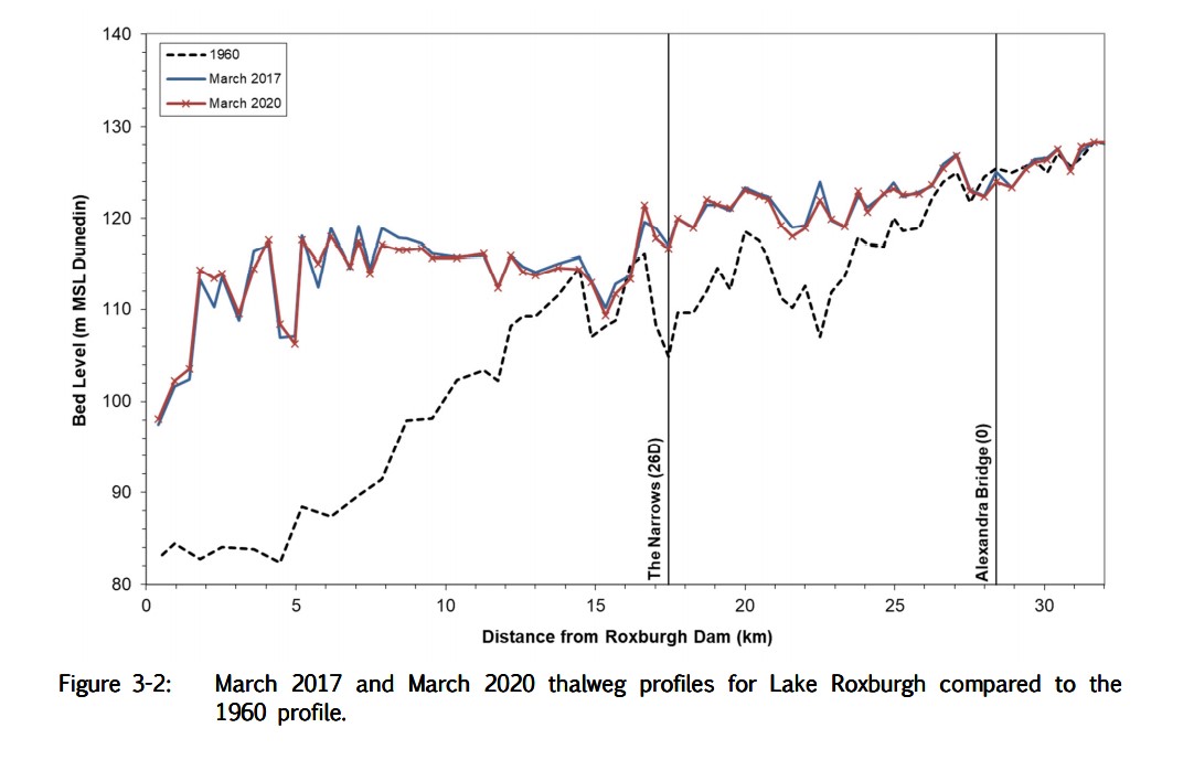
The conclusion of the report was that, little effect of lowering the level of sediment was evident and this is now consistent with several of the reports which shows this trend. Graph 3-2 from the report demonstrates this. The dotted line is the original survey (1960) carried out shortly after Lake Roxburgh was formed in 1956. Flushing has been carried out since the new consents went into effect in 2007 and the lake bed level below Alexandra Bridge and The Narrows is still higher (by up to 10 meters) than the original level, resulting in any flood being higher than it would otherwise have been had the sediment not been there. This in turn means Alexandra is under greater risk of flooding since the dam was built and that this risk is not being managed by the Flushing Program as envisaged at the time the consents were issued
(Table 3-2).
Another conclusion of the report was that a larger flood might be more effective as the lake bed velocities would be greater and thus transport a greater amount material. A larger flood might also spill over the stop banks built to help protect Alexandra because the silt has not been removed, Catch -22. The flood that occurred last December was interesting in that one more rain event of similar size to the preceding events could have over topped the stop banks and caused it to flood Alexandra again. Lakes Wakatipu, Wanaka and Hawea were already full so with no storage the excess waters would have had nowhere to go other than down the rivers. Fortunately, this did not happen (this time) but ORC has been asked to model what would have happened in order to better inform the potentially affected communities.
Note the lake level at Roxburgh Dam is only lowered for flushing to a point which still allows CE to generate electricity. It could be lowered significantly further, which would have the effect of increasing the bed velocities and transport all of the sediment down the river to the sea. It is clear that the risk of flooding in Alexandra due to sediment is at least as high as it was in the last major flood. Given the likely real but unquantifiable increases in rainfall due to climate change, it is imperative that this only realistic approach to reducing the lake bed sediment be addressed without delay.
The second report submitted to the ORC by CE is titled “Bed of the Kawarau Arm of Lake Dunstan, LANDSCAPE AND VISUAL AMENITY MANAGEMENT PLAN: 2020 – 2025, Draft for Consultation”.
The report documents the ongoing sedimentation of the Kawarau arm and proposes no additional action other than to continue monitoring what is happening. It notes the formation of “wetlands” i.e. sandbars with a “relatively dense cover of raupo and willow”. It concludes “The development of the sandbars, while changing the river bed, is part of the landscape”. Also, “Noticeable geographic features other than the lake include the confluence of the Kawarau Arm and its distinctive sediment-laden river flow mixing with the aqua blue, lake-sourced flow of Clutha River component of Lake Dunstan”. This “sediment laden” effect was previously only noticeable when the Shotover river was in flood, now it happens with any minimal flow increase because of the existing amount of deposited silt in the Kawarau arm. While these effects were well canvased at the time of the consents, were the communities made aware of the practical realities of the model chosen to manage the sedimentation e.g. sandbars with logs stranded on them, boat ramps closed, boating restricted, beaches disappeared, discoloured water occurring more frequently? Many of the benefits proclaimed by having a lake are no longer available in the Kawarau arm.
The model chosen to manage the sediment is to allow it to fill all the way to the Clyde dam after which it will be drawn through the penstocks and into Lake Roxburgh, where a similar process will occur. This was planned to take about 100 years for Clyde, and is on track as the sediment has reached the Cromwell junction, in 2020 as predicted.
Coming back to the hourglass analogy - it begs the question why the hole was not drilled at the beginning to allow the sediment to pass rather than accumulate. There are low level gates in both dams so the lakes could be reverted to rivers during the flood events which would take the sediment out to the sea, just as nature managed the issue for thousands of years.
The Guardians of Lake Dunstan have made a submission on the report to the Central Otago District Council (CODC) which includes a legal opinion to support their view that not enough is being done by CE to manage the negative effects.
There are no Guardians of Lake Roxburgh. Perhaps there need to be?
CE is one is the largest listed companies on the stock exchange and reports to its shareholders. The revenue it gains from the electricity generated at the two dams contributes a significant proportion to its bottom line (and dividends), which it will want to protect.
The ORC is a rate payer-funded organisation with many roles, one of which is to act as a monitor of consents. New rules from the government require regional councils to work with communities and Tangata Whenua to find out their vision for the future of their waterways in areas called Freshwater Management Units (FMUs). The ORC has been conducting workshops canvasing ideas. The governments new 3 water review (drinking, waste and storm) will also impact on this discussion. Does the ORC have the resources and funds to manage this particular issue on behalf of communities? Should funding be made available to communities to carry out their own research?
Water has long been the new “gold” in Otago and its value will continue to increase. The current model to manage water is changing and communities need to be sure their interests are being attended to. Are we implementing adequate resources and representation to ensure the generations that follow will feel they were well served?
- Grant Campbell


