Forecast wild weather has eased at the top of the South Island, but a raft of warnings are now in place for much of the North Island.
The Marlborough District Council this afternoon said the region appeared to have escaped any major storm-related impacts today.
This evening, MetService lifted its heavy rain alerts for the top of the South Island.
However, the wild weather is tracking north, bringing heavy rain, severe thunderstorms and wild winds to many areas.
Severe thunderstorm warnings have been issued for Taranaki, and emergency operations centres have been set up in New Plymouth and Hāwera as heavy rain and thunderstorms roll across the region.
Taranaki Civil Defence Emergency Management controller Todd Velvin said the region was experiencing widespread surface flooding.
Velvin said the Waiwhakaiho River in New Plymouth was also starting to rise and the Huatoki River underpass had been closed at Puke Ariki Landing in the city.
There were also reports of garages and basements flooding as New Plymouth's stormwater system struggles with the deluge.
Further north, Ruapehu's mayor says the area is bracing for a downpour this evening, but is hopeful the worst of the wild weather will bypass them.
Civil Defence is on standby in Taumarunui, which is under a heavy rain and thunderstorm watch until later this evening, alongside a heavy rain warning in place for Tongariro National Park.
Mayor Weston Kirton says they're expecting a 'dump' around 7pm but says it looks like they'll dodge a bullet.
Earlier, Marlborough Emergency Management Incident Controller Chris Faulls said they were remaining vigilant and prepared "should there be any further impacts".
“This rain was predicted to hit us harder than what has eventuated but that is a good result for us.”
A slip on Northbank Rd was being assessed and a decision would be made tomorrow on whether it could be opened temporarily to let residents in.
There are 97 properties and about 250 people living beyond the slip site, Faulls said.
Nelson, Tasman and Marlborough remain under states of emergency for now.
Civil Defence earlier today warned people whose properties flooded last week to prepare for more heavy rain and to consider staying elsewhere.
By Wednesday night, six homes in the Brooklyn area, bordering the Motueka River, had been evacuated with some staying with friends and family and accommodation provided to others.
Nelson Tasman Civil Defence controller Alec Louverdis told Midday Report that while so far the weather has not been as bad as expected, they were still planning for the worst-case scenario.
He said there had been no further evacuations today and the Brooklyn ones were pre-emptive.
"A very small number of people were asked to evacuate - we'll see what the rivers do by 6pm before we let them back.
"We have evacuation plans in place but these have not been triggered."
The biggest concern was the Wai Iti and Brooklyn area, he said.
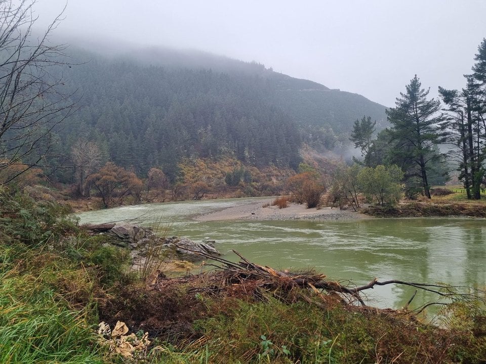
The heaviest rain and swiftest-rising rivers were in Golden Bay, which was in line with modelling, Louverdis said.
The main concern was the areas that flooded last week, because those rivers were still running high and the land was sodden.
Louverdis urges people to stay off the region's roads, many of which are closed or have restrictions on them.
Emergency Management Minister Mark Mitchell says he had asked his officials to work closely with Chorus to restore internet service for Golden Bay.
He says a lot of planning had been done in preparation for the weather.
"I've got a very high degree of confidence that people are going to get the support that they need".
Mitchell - who was in Nelson on Sunday - says it was "highly likely" he would be heading back down south tomorrow "depending on what unfolds in the next few hours".
MetService on Thursday afternoon updated its weather alerts for the area: an orange heavy rain warning for the Tasman District north-west of Motueka has been downgraded to a heavy rain watch, for four hours from 1pm today. The forecaster said rain was easing but a watch would be maintained through to this evening.
An orange heavy rain warning remains in place for the rest of the Nelson-Tasman District south-east of Motueka, and Marlborough north of the Wairau River, for 10 hours from 9am today.
MetService said to expect 60 to 80mm of rain about the sounds and ranges on top of what has already fallen, and less elsewhere, with peak rates of 15 to 25mmh, mainly about ranges.
Civil Defence said it would be keeping a close on eye on hotspots such as the Motupiko and Brooklands rivers, and townships including Tapawera and Riwaka, but everywhere that flooded last week was potentially at risk.