Civil Defence staff have been working overnight to reduce the risk of a breach of an embankment in Balclutha.
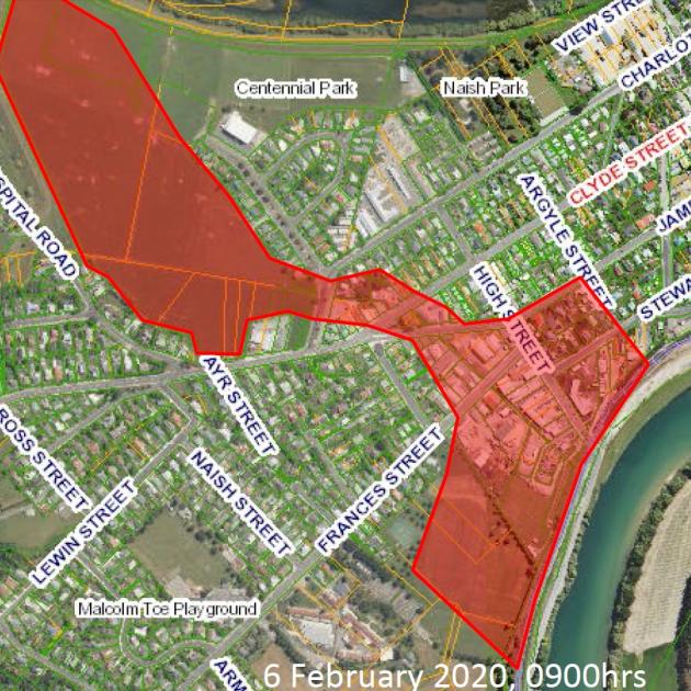
The Clutha District Council released a revised map today which shows a significantly reduced "red zone" of the areas which could be at risk if the Hospital Road Detention Embankment failed.
Civil Defence staff have been pumping water out of the embankment during the night and will continue to do so throughout the day, the CDC said.
Residents who were in the red zone yesterday but are not included in the revised map today can now return home, it said.
"However, anybody in the previously affected area should still be cautious."
The Civil Defence will get in touch residents whose properties have remained in the red zone today, it said.
"It will still be your choice if you feel you need to evacuate, or if you have evacuated to remain so until more progress to reduce the risk is made."
The risk will be reassessed later in the day.
Clutha Mayor Bryan Cadogan said caution remained, although he was pleased with the overall response to the flood emergency during the past week.
"We're still advising about six properties to remain evacuated while the Hospital Rd water is pumped away, but the Clutha River is sharply down from yesterday's highs and continuing to fall."
The "major task" of road inspections would continue during coming days, and routes would continue to be opened when it was safe to do so, he said.
"The Owaka Highway from Balclutha into the Catlins is now reopened, although we're told the Southland end at Fortrose remains closed at this stage."
A welfare centre in Balclutha hosted about 30 stranded travellers last night.
"There's been a magnificent community spirit shown by local people, with offers of bedding, emergency accommodation and food. It's been the district at its best."
Mr Cadogan said the Clutha Civil Defence team would continue to monitor the situation closely, as further rain was predicted on Saturday.
"We've been lucky in that, had this event been only marginally worse, there would have been huge ramifications. With river levels already high, let's hope the weekend brings a normal rain, rather than the high intensity we've experienced."
Clutha District Roads
Flood waters continue to subside, but we are now seeing significant widespread damage throughout parts of our 3000km network of roads.
"We cannot put signs up at every damaged road, and Council contractors have not been able to check every road yet. It is imperative that everyone takes care on all roads in the district, drive to the conditions, and remain vigilant for areas of water or damage to the road.
"We've also been getting reports that people have been tampering with some of the road closed signs we have out there. We urge everyone to keep themselves safe and give consideration to the safety of others."
Council contractors are starting to work on the network to fix immediate damage and make some roads passable.
Sealed roads; closed due to major seal damage. Once open caution will be required.
- West Otago Rd – hopefully open by the end of the day
- Greenvale Rd/Ardmore Rd corner – hopefully open by the end of the day
- Clydevale Rd will to remain closed until further notice as there is a large hole at one end of the scouring
- Barnego Rd is closed at the Balclutha Bridge due to water spilling over the flood banks.
- The road from Balclutha to Beaumont (Clutha Valley Rd, Clutha River Rd and Rongahere Rd) is closed
Roads now open
- Kaitangata Highway
- Riverbank Rd is passable but is still closed between Smith Rd and Renton Rd due to a slip


