PHOTO
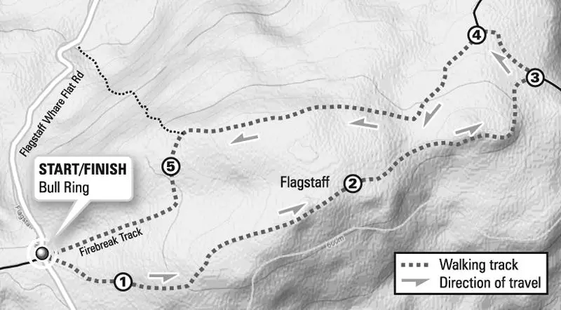
- Estimated time to complete: 1 hour return
- Distance: 2.7km
- Climb: 170m
This is an excellent walk on a well-maintained track only a short drive from the city.
From Flagstaff's comparatively flat top, there are excellent views of the whole of Dunedin.
The Snowy Mountain Track was an early bullock track and stock route over Flagstaff. Taking the tussock tops avoided the dense bush of lower routes. Due to mist and cloud, it was easy to get lost. In 1850, donations were called for to allow flagstaffs to be erected to mark the route, hence the name.
The walking track starts on the right of the Bull Ring and climbs initially through an area dominated by manuka scrub. The manuka is gaining dominance over the shorter snow tussock, mountain flax and astelia.
As the track steepens, an area of tussock grassland burnt in the 1976 fires is reached. The tussock top is comparatively recent. Only 200 to 300 years ago, forest covered the whole area.
Periodic fires have maintained the tussock grassland. The last major accidental fire over Flagstaff was in March 1976 when a hot, spring fire burnt off up to 100ha. In September, a further 1.5ha was deliberately burnt in a cool, autumn fire.
The burnt and unburnt areas have been closely studied and there has been some debate as to whether fire should be used to maintain the tussockland. Current policy is to allow the natural succession back to shrub land and forest, and maintain some tussock land in areas to preserve that vegetation type and the views.
From this part of the track [1], there are good views of the Taieri Plain and the township of Mosgiel. Saddle Hill is to the left and Maungatua, another flat-topped hill, in the distance beyond Mosgiel.
The track climbs to the left and after a last steep section emerges on to the rolling top of the hill. Here the tussocks are shorter and there are numerous volcanic rock outcrops. The track twists its way through the rocks to reach a low summit, marked by a drain pipe [2].
A plane table set in the rock describes features of the panoramic view. The rocks make an excellent place to rest, giving shelter from any wind and opportunity to examine the wide variety of small plants that live between the larger tussocks and flax bushes. Return down the track to the Bull Ring.
Firebreak Track option
Continue east along the track and descend to a small saddle. Turn left on the short connection track to the Firebreak Track [3]. Return to the Bull Ring using the Firebreak Track passing the skid site [4] and fire-fighting pond [5]. This can be very muddy in wet conditions.
• This is an extract from Dunedin Tracks and Trails, an illustrated guide to Dunedin walks, tramps and mountain bike routes by Antony Hamel. It is available at Dunedin bookshops and the Visitor Centre.