PHOTO
Severe thunderstorm warnings have been lifted for parts of Otago, but the South is still in line for more stormy weather going into the evening.
Shortly before 3pm MetService issued severe thunderstorm warnings for Dunedin City, Waitaki and Central Otago, but in an update about 3.40pm advised they had been lifted.
Several warnings were also issued for parts of Canterbury, including Christchurch city, throughout the afternoon.
The forecaster earlier issued a severe thunderstorm watch for much of the South Island, from noon to 9pm today, and this remained in effect at 3.45pm.
The watch covers Dunedin, North Otago, Central Otago, Southern Lakes, Clutha, Southland, Fiordland, Christchurch, the Canterbury Plains and the Canterbury High Country.
MetService said the storms could produce localised downpours of 25 to 40mm/h and/or hail larger than 20mm in diameter.
MetService meteorologist Silvia Martino earlier said a cold unstable air mass had been causing thunderstorms across the southern regions for the past two days.
"And if it’s looking like there’s a high risk again [today], there will be another severe thunderstorm, watch for large hail."
Hail could cause significant damage to crops, orchards, vines, glasshouses and vehicles, as well as make driving conditions hazardous, she said.
"Stay off the roads if you can, and if you’re outside and you feel threatened, take shelter immediately.
"These storms are definitely something for people to watch out for."
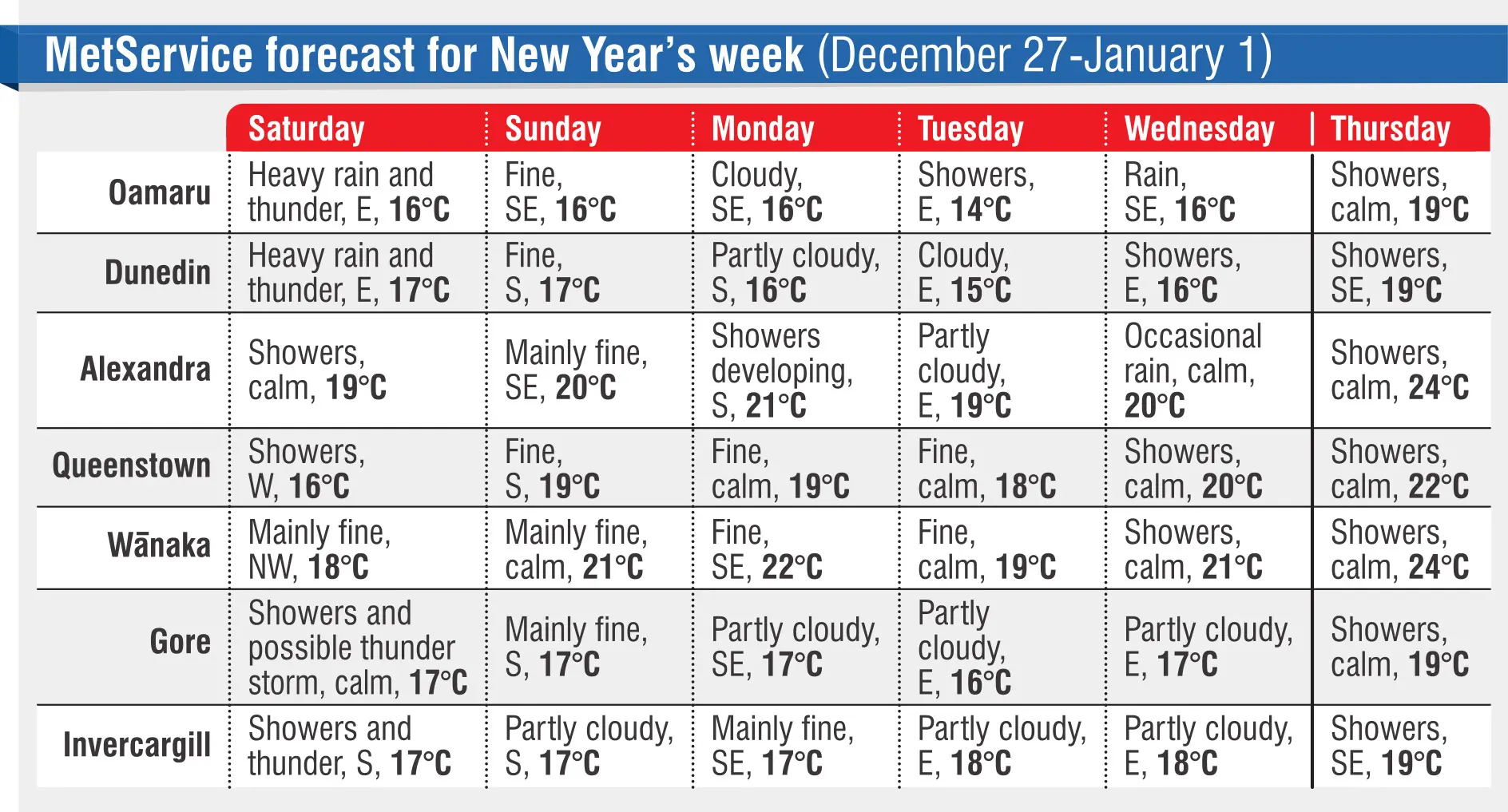
As for next week — which includes New Year’s Eve and New Year’s Day — the news was not good so far, she said.
"It’s an unfortunate time for Dunedin in particular, because we’ve had a bunch of westerly rain, and that mostly stays on the West Coast, which is not too bad for Dunedin.
"But what we’re looking at in the days to come is a low pressure system sitting out to the east of the South Island, directing easterly rain into Dunedin, which is, unfortunately, not lovely."
So the forecast for New Year’s Eve and New Year’s Day was for temperatures around 20°C across all the main centres in the southern regions, and rain at some stage during the two-day holiday.
However, that was a long-term outlook at this stage, and things could change between now and then, she said.
Otago and Southland were not the only places getting a lot of wet weather lately, Ms Martino said.
"Unfortunately, at the moment, extended-range models are looking like it will be damper for much of the country, which is not what anyone wants to hear in the summer holidays."
MetService was eager to let people know as soon as there was any sign of more stable, drier weather on the horizon, she said.
At this stage, it looks like the best place to be on New Year’s Eve is Southland, where it is only expected to be partly cloudy.