MetService said there was a front moving east across the country which was expected to bring heavy rain, and strong north to northeast winds.
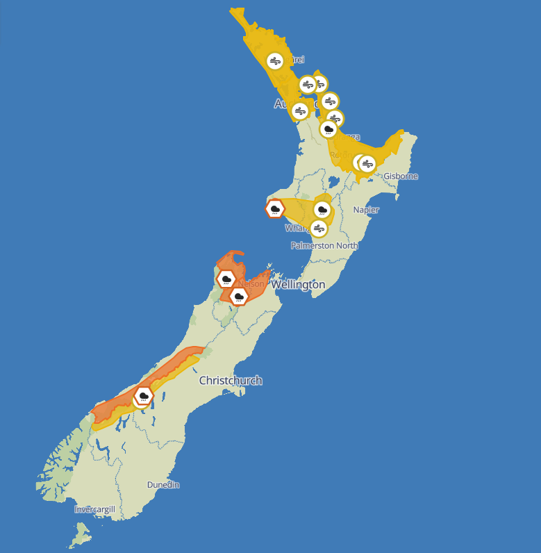
Orange rain warnings
Orange rain warnings were in place for the Tasman region from Motueka westwards, Tasman east and south of Motueka, Nelson and Marlborough west of Havelock and north of the Wairau River, Taranaki Maunga and the ranges of the Westland District.
The warning for Tasman from Motueka westwards would be in place from 2am to 6pm on Tuesday, 29 July, and had a moderate chance of upgrading to a red warning.
People in the region were to expect between 130mm and 150mm in a strong northerly flow. Rainfall intensities could reach 15 to 20mm per hour, especially from mid-morning until early afternoon, MetService said.
Tasman east and south of Motueka, Nelson and Marlborough west of Havelock and north of the Wairau River would be under orange warning from 5am on Tuesday until 9pm, again with a moderate chance of becoming red.
There, 100mm to 130 mm of rain in a strong northerly flow was expected, with rainfall intensities of 15mm per hour possible, especially during the afternoon.The Nelson Tasman region has already been gutted by two major floods since late last month and is in an official recovery period.
Residents were advised to clear their drains and gutters to prepare for heavy rain, and to avoid low-lying areas and drive cautiously, MetService said.
Taranaki Maunga was under orange warning from 7am on Tuesday to 1am Wednesday, while the ranges of Westland District were under the same from 1am to 5pm Tuesday.
Both warnings had a minimal chance of upgrading to red.
Heavy rain and strong wind watches
Heavy rain watches would also be in place for many regions around the motu between Monday and Tuesday, and in some cases through to Wednesday.
Watches for the Coromandel Peninsula, Bay of Plenty and an area about and within 15km east of the Divide from Arthur's Pass to the Dart River had a high chance of upgrading to a warning, while those for for the Central North Island mountains, Northland and Auckland, including Great Barrier Island, all had a moderate chance of upgrading.
Along with their rain watches, Northland, Auckland and Great Barrier Island would be under a strong wind watch from Monday evening, with both watches given a moderate chance of upgrading to warnings.
Strong wind watches would also be in place for The Coromandel Peninsula, eastern Waikato and the Bay of Plenty for most of Tuesday, and about and south of the mountains and high-country from Taranaki to the Central Plateau from late Monday evening through to Tuesday evening.
The Coromandel Peninsula, eastern Waikato and the Bay of Plenty had a moderate chance of upgrading to a warning, while the areas about and south of the mountains and high-country from Taranaki to the Central Plateau had a high chance of upgrading, MetService said.


