Wakatipu Walkabout: Ben Lomond range

Priceless views, such as this of Cecil Peak, are pinpointed by the monument dial which marks the...
Priceless views, such as this of Cecil Peak, are pinpointed by the monument dial which marks the top of Ben Lomond. Photo from DoC.

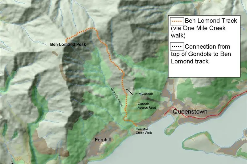
Ben Lomond is the huge mountain range that towers higher than Coronet Peak over Queenstown and is one of the most popular summer day-walks, as the summit offers breathtaking 360deg views of the Wakatipu.

However, Department of Conservation Queenstown Regional Visitor Centre ranger Tyler Rose said trampers needed to be suitably prepared for the challenging hike and the changeable alpine climate.

Layers of warm clothing, waterproof jacket, water and food were essential, he said.

"People should allow for six to eight hours return, depending on fitness. Trampers should choose a day with a good weather forecast and allow for plenty of daylight hours to complete the tramp."

Mr Rose said there were several ways to tramp the 1748m to the top of Ben Lomond.

"For the purists, you could start at Lake Wakatipu level and connect to the Ben Lomond Track via the One Mile Creek Walk. The sign-posted creek walk has steep and occasionally slippery parts and begins near the Fernhill roundabout.

"The walk takes you past one of New Zealand's first hydro-electric power stations, through one of the closest native beech forests to Queenstown and meets the unsealed Skyline Gondola access road after 30 to 45 minutes.

"On that road after a couple of minutes you see the signs for the start of the Ben Lomond Track."

For those short on time, the second main way to start the track is to take a gondola ride to the terminal building then stroll along the track that sidles across ridge to meet the track start.

Some trampers choose to take the gondola on the return journey, Mr Rose said.

A third access way is by the gondola access road off Lomond Cres to the west of the central business district.

The road goes through non-native Douglas fir stands, which threaten to spread up the mountain and dominate native vegetation if not kept in check by wilding pine control efforts.

The road then connects with the mostly well-formed Ben Lomond Track, which takes walkers through pockets of remnant silver and mountain beech forest then into alpine tussocks and Dracophyllum at about 800m towards the Ben Lomond Saddle.

"The saddle is a low-point between the neighbouring Bowen Peak to the east and Ben Lomond Peak to west," Mr Rose said.

"From the saddle, the last pitch to the summit of Ben Lomond is steep and rocky. Care is required and, after 45min to one hour, the peak is reached."

A dial on a rock monument swivels 360deg and identifies the ranges, including Mt Earnslaw/Pikirakatahi and Mt Aspiring/Tititea.

Experienced and well-equipped trampers may choose to hike from the saddle to Arthurs Point via the four to five-hour Moonlight Track.

The track was not maintained by Doc and crosses private land, Mr Rose said.

"Please respect the landowners's rights. Walkers should carry a map of the area and compass."


Add a Comment


Advertisement

OUTSTREAM