Comment permalink

Simeon Snyder takes a shortcut up  Duddingstone Steps from North Rd. PHOTO: PETER MCINTOSH
Simeon Snyder takes a shortcut up Duddingstone Steps from North Rd. PHOTO: PETER MCINTOSH
Who doesn’t love a shortcut, a hack, a way to do things more quickly and easily? And what could be better than getting out and exploring our beautiful little city? So, Bruce Munro has compiled Dunedin’s top 10 shortcuts:  a guide to the best clever, hidden, forgotten or, in some cases, barely existent paths, steps and tracks in Dunedin.

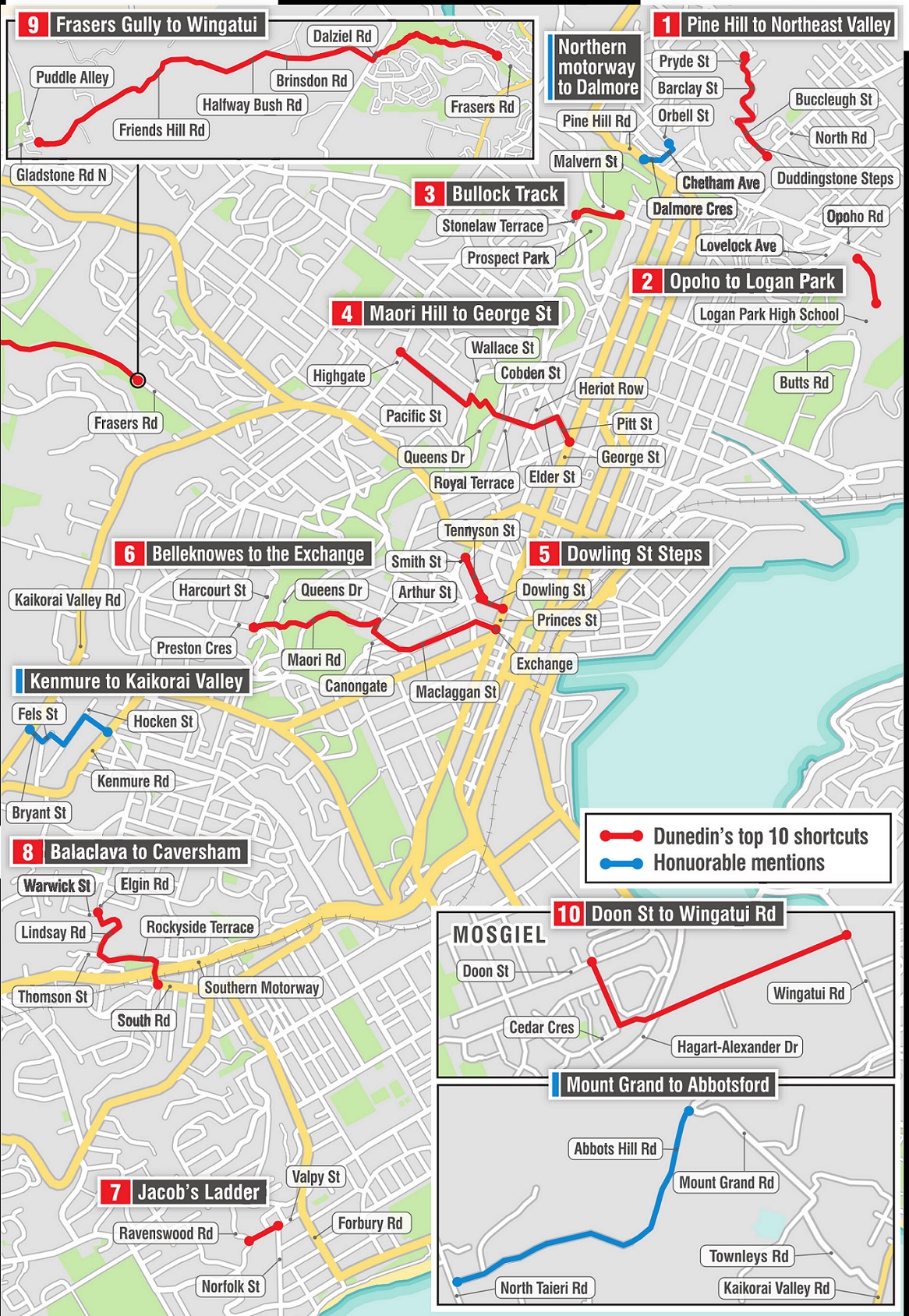
Pine Hill to North East Valley

At the eastern border of Pine Hill is a "driveway" that connects Pryde St with Barclay St, at the top of Opoho. It is a steep and winding descent — 124m of altitude over 450m of crow-flight distance — down Barclay St, which is renamed Buccleugh St at the penultimate bend of your journey. When you reach the former Santa Sabina convent, make sure to take Duddingstone Steps for a Shanks’ pony escalator ride down the final 100m to North Rd, North East Valley. In all, this 850m shortcut takes about 12 minutes to walk, compared with a 32 minute, 2.3km walk down Pine Hill Rd.


Opoho to Logan Park

Opoho to Logan Park through the bush. PHOTO: PETER MCINTOSH
Running late for first period on Monday morning? Or for Saturday morning sports? In the bush next to the swings behind the Scout Hall on Opoho Rd is the entrance to a track that will take you directly to Logan Park. No need to bother with soft options such as walking down Lovelock Ave or taking the well-formed track from the Northern Cemetery. This shortcut has been fashioned by the feet of generations of school pupils forging a hurried path to secondary education. It is pleasant and then steep and emerges atop an embankment edging the driveway that runs past the high school tennis courts. And it is indisputably the quickest route from Opoho to Logan Park.


Bullock Track

The Bullock Track down to Woodhaugh. PHOTO: STEPHEN JAQUIERY
In the early days of Dunedin, this was the cliffside path cattle were led along on their way to the works. Now it is a handy shortcut for anyone who needs to quickly get from the leafy suburbs to the city’s student quarter, or back again. The elevated entrance to the Bullock Track is off Stonelaw Tce, next to Prospect Park. A 300m stroll later, you are in Malvern St, North End.


Maori Hill to George St

There is no need to believe the trip from Highgate to the city’s retail high street necessitates a car ride. Opposite Columba College, take the footpath steps down Pacific St, passing a bevy of lovely houses and sections. Cross Wallace St for a tranquil walk through the Town Belt, emerging at Olveston historic home. Walk past St Hilda’s Collegiate, in Cobden St, take a short flight of steps, cross Heriot Row, and take the longer steps to the top of Elder St. At the end of Elder St, turn right into Pitt St, from where George St is a mere 120m. This pleasant, 1.3km walk takes less than 20 minutes.

Dowling St Steps

The Dowling St steps shortcut down to Princes St. Photo: Peter McIntosh
Before Otago’s gold rush, Dunedin was split in two by Bell Hill. When a cutting was put through linking the Octagon to the Exchange, and then later widened, it left a raised "back wall" at Dowling St. In the late 1920s, concrete steps were built here, complete with gun emplacement. The obsolete field gun was removed during World War 2 to avoid making the area of the Chief Post Office an enemy bombing target. And although the area can attract less desirable attention at night, during daylight hours the steps make an excellent, if slightly odorous, shortcut from Tennyson St to Princes St.


Belleknowes to the Exchange

From Queens Drive down to Maori Rd. Photo: Stephen Jaquiery
Standing quietly at the corner of Preston Cres and Harcourt St, in Belleknowes, with views across bush to the Otago Peninsula and Harbour, the centre of town seems a world away. In fact, if you know the shortcut, it is less than 2km, letting you be in among the bustle in well under half an hour. Take the shallow steps (more like an undulating path) down to Queens Dr, cross into the Town Belt and take the path to Maori Rd. Follow Maori Rd until you can take a sharp right in to Arthur St and follow the steps that lead down to Canongate. Across the road, the steps continue down to near the meeting point of Serpentine Ave and Maclaggan St. At the bottom of Maclaggan St, at the Speight’s Brewery, turn right in to Rattray St and the Exchange is directly ahead.


Jacob's Ladder

The 279 steps of Jacob's Ladder emerge onto Ravenswood Rd and a heavenly view. Photo: Peter...
The 279 steps of Jacob's Ladder emerge onto Ravenswood Rd and a heavenly view. Photo: Peter McIntosh
Want to quickly gain some height for a view out over South Dunedin to the Pacific Ocean? Find your way to the corner of Valpy and Norfolk Sts, St Clair, where Jacob’s Ladder begins with a beguiling, gently sloping path. It is a character-building shortcut; 279 steps in a 200m-long straight line. But climb that ladder and you will emerge on Ravenswood Rd to be rewarded by heavenly views.


Balaclava to Caversham

The steps down to Caversham from the corner of Elgin Rd and Warwick St. Photo: Peter McIntosh
How many times have you wished there was a shortcut from Balaclava to Caversham? Well, stop wishing and start walking. Descend the steps at the corner of Elgin Rd and Warwick St on to an arcing path that empties out on to a driveway at the top of Lindsay Rd. Follow Lindsay Rd until you can turn left into Rockyside Tce. Turn right into Barnes Dr, cross the Southern Motorway at the lights and before you know it you are stand at the top of Caversham’s main street, South Rd.


Doon St to Wingatui Rd

Heading for Wingatui from Doon St Mosgiel. Photo: Stephen Jaquiery
Looking for an interesting 15-minute walk to transport you from suburbia to a rural idyll? Park the car in Doon St, Mosgiel, and take the pathway opposite the Salisbury Pl entrance to Chatsford Retirement Village. Cross the end of Elmwood Dr and continue until you can turn hard left at Cedar Cres. After about 100m, cross Hagart Alexander Dr. Suddenly, you are in the country. Spread before you is a straight, 750m-long country lane surrounded by calming fields. Enjoy.

Plain sailing

Fraser's Gully to Wingatui

This is the ultimate shortcut, if a long one. But who would have thought you could walk between Kaikorai Valley and Mosgiel through bush and countryside with the company of practically no cars? It’s not via Three Mile Hill but just south of that and is a mixture of quiet roads and rough vehicle track.

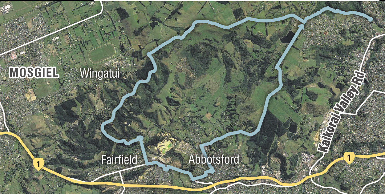
The starting point at Fraser’s Gully is remarkable in its own right. It’s a large pocket of native forest containing kaumatua-sized podocarps and a loop walk. The track is superb quality and looks wheelchair accessible for the first few hundred metres, passing idyllic creek-side picnic spots with tables. Recent slips have meant some new track work,which is a bonus at this time of year.

At the top is Dalziel Rd, where the back route begins. Within eyesight of Fraser’s Gully is a no-exit road at Mt Grand water treatment plant that leads you down this mind-blowing new route. The road peters out and becomes rocky track with unusually angled views for those of us used to travelling Three Mile Hill.

After a bit more road the first view of Mosgiel lets you imagine you’re a pilot about to land at Momona. There’s the whole Taieri Plain stretching out below, framed by Middlemarch’s Rock and Pillars to the right and to the left, miles of south coast and sea.

Walking poles are handy for the clay underfoot on this bit. And you know it’s winter when you’re walking over frosty bits at 2 in the afternoon.

Fraser's Gully. Photo: Clare Fraser
The track curves around the edge of small hills, the Pearl of the Plain revealing itself more and more around each bend. Near the bottom is a patch of eucalypts that were like walking into a 3-D New Age relaxation recording as a hanging piece of eucalypt bark occasionally dinged a tree trunk like a wind chime. Pure rehab. Or maybe you had to be there.

Regardless, if this walk was in Wellington it would be full of stressed out office workers with head down and headphones on, trying to come down from their awful week. But here there were just a few locals who know how good they’ve got it, some calm, relaxed horses and the calls of distant spur-winged plovers.

The Wingatui Racecourse is at the bottom of the hill but just before that is a marked track to Chain Hills Rd across farmland with amazing views.

Psyching up for my return walk I texted a local friend to say I was in the neighbourhood and wouldn’t you know it, she offered a ride back to my car. It was only polite to accept.

PHOTO: CLARE FRASER
PHOTO: CLARE FRASER
If you’re keen on making a day of it, there’s another option for a completely different return route. First left off Chain Hills Rd is a dead end road that in fact isn’t dead for pedestrians — after climbing a stile you briefly cross another farm with views back towards the day’s starting point, then arrive down in suburban Fairfield. At this point it’s back to the reality of whizzing cars as you head towards Sunnyvale but there’s a lovely landscaped detour for part of the way and maybe pukekos for company.

At the sports centre turn at Thomson St to get to the edge of town and on to another rural adventure. Once again, there’s the treat of crossing farmland up an official accessway before you reach Dalziel Rd again and wend your way back to the start.

 - Clare Fraser


HONORABLE MENTIONS

 • Kenmure to Kaikorai Valley. Take the steps off Kenmure Rd to Hocken St, then the steps off Hocken St to Fels St. Head around the corner in to Bryant St and straight down to Kaikorai Valley Rd.

 • Northern motorway to Dalmore. A path called Dalmore Cres comes off SH1 about 30m above Bank St. It joins with a path named Chetham Ave which emerges at the end of Orbell St.

 • Mount Grand to Abbotsford. Above Kaikorai Valley, on the outside of a hairpin bend on Mt Grand Rd, a paper road called Abbots Hill Rd wends its way down to where its properly formed namesake leads the traveller to North Taieri Rd, Abbotsford.

What have we missed?

Is there a shortcut you take, or know of, that we’ve missed? Either in Dunedin or elsewhere in the region? Let us know at odt.features@odt.co.nz.

Comments

View all

While all very well and good, what you have to remember is not everybody can walk or is mobile, I also wonder about the legality of some of these walks as from what I read, you are walking over private land ie"across farmland" "cross another farm" "Once again, there’s the treat of crossing farmland", is permission obtained beforehand or are you crossing illegally?.

ODT Editor's note: "Each track across farmland had a sign indicating it was a public road. The Walk On and Shortcuts series has included a range of walks and tracks of various lengths, including some more accessible options. The Plain Sailing walk included mention that the Fraser's Gully track appears wheelchair accessible for the first section"

If you can't walk, or are immobile, then this article is not aimed at you. There's no offence intended by that statement, it's just the obvious truth. Just like an article for great swimming spots would be useless for people who cannot swim.

There are a lot of 'paper roads' around the city, which are unformed roads/usually tracks which are legal to walk or bicycle along, which is what is likely being referenced in this article. I know the Abbotsford to Mt Grand track is such a road. And the Halfway Bush road to Wingatui. Possibly even the Chain Hills track.

Click here to read more: https://www.dunedin.govt.nz/__data/assets/pdf_file/0009/132795/Tracks.pdf
Scroll down to; APPENDIX A - ISSUE DISCUSSION

And to confirm, there is a track from Wingatui to Chain Hill.
https://www.dunedin.govt.nz/do-it-online/maps-and-photos/tracks-and-trai...

So your statement "Just like an article for great swimming spots would be useless for people who cannot swim", does this go for people who cannot swim but are happy to sit beside or wade around the swimming spot?, are they to be excluded from said swimming spot?.

Old cut to Carisbrook from Fitzroy St: Steep Street to Eglinton Road (Zingari).

Dunedin is charming

View all