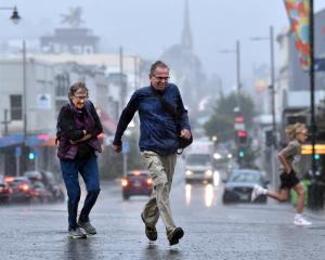
Our first taste of autumn has arrived with heavy rainfall and the promise of a "noticeable drop in temperatures" over the next few days.
Concerns about flooding overnight — particularly in the South Dunedin area — prompted the Dunedin City Council to set up sandbag stations at the Ice Stadium in Victoria Rd, and at Mosgiel’s Memorial Park yesterday afternoon.
A welfare centre was also opened at the Mercy Room, at Catholic Social Services in Macandrew Rd, for residents who needed to leave their homes.
Up to 90mm of rain was forecast to fall between 11pm yesterday and 11am today, at peak rates of up to 20mm per hour.
Areas between Balclutha and Waikouaiti were expected to receive the most rain, and Southern police advised residents to avoid any unnecessary travel.
MetService meteorologist Jessie Owen said active weather was swarming over the southern regions today, courtesy of a deep low which was forming to the east of the South Island.
"This low is expected to direct a strong, cold southerly change up the country.
"Heavy rain warnings for Southland, Clutha, and Dunedin have been issued, along with heavy rain watches for the remainder of Otago and Canterbury.
"A strong wind watch for south-to-southwesterly winds is also in force for Dunedin, North Otago, and the Canterbury coast and plains, while Banks Peninsula is under a strong wind warning and can expect gusts of up to 120kmh."
Mr Owen said heavy southwesterly swells, brought on by the southwesterly winds, were forecast to affect western coastlines and eastern coasts of the South Island today and tomorrow.
"A noticeable drop in temperatures will be felt across the South Island today, following the southerly change.
"Overnight temperatures are set to plummet through the single digits; Alexandra, Wanaka, and Queenstown are forecast to drop to 3degC overnight [tonight], Taumarunui can expect 3degC and Taupō 4degC overnight Wednesday."
He said snow might fall as low as 800m above sea level in the eastern South Island in the heaviest precipitation associated with this southerly change.
Most of the severe weather would be concentrated over the South Island this week.
Western areas would have heavier rain than the east, and colder temperatures could be expected throughout, following the southerly change.
From tomorrow onwards, the active weather was set to move away to the east as a new high pressure system from the Tasman Sea pushes its way over the country.
"This will mark the return of more settled weather to round out the working week, although those colder nights will remain," he said.