Heavy rain and severe gales are set to batter parts of the South Island today and snow is forecast for some alpine passes, including the Milford Road, which has closed.
A strong northwest flow moves onto the island from the afternoon, bringing wild weather up the country.
MetService has issued a severe rain warning for the headwaters of the Otago lakes and rivers from 1pm to 9pm.
Between 70mm to 90mm was forecast to fall about the main divide, and 60mm to 70mm within 15km farther east. Peak rates of 10 to 20mm/h were expected about the divide. The snow level was 1800 metres.
A heavy rain watch is in place for the headwaters of the Canterbury lakes and rivers south of Arthur's Pass from 4pm until midnight.
Rainfall amounts may approach warning criteria within 15km east of the main divide.
Strong winds
A strong wind watch is in place for the Queenstown Lakes District, Central Otago, Clutha District north of Tapanui and Southland north of Riversdale from noon until 9pm.
Northwest winds may approach severe gale in exposed places, MetService said.
Further north, a strong wind warning has been issued for the Canterbury High Country from 4pm until midnight. Severe gales northwest gusting to 120km/h in exposed places was expected.
People were advised to prepare their property by securing items that can be picked up by strong winds, and to drive cautiously.
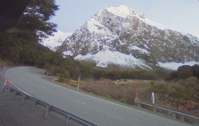
Snow for alpine passes, Milford Rd closed
Southland's Milford Road closed from East Gate (Hollyford) to Donne River (Westgate) at 2pm today due to heavy rain increasing the avalanche hazard and overnight snow to road level.
The avalanche risk was lifted to moderate this afternoon.
MetService said rain was expected to turn to snow showers tonight until late tomorrow morning. Between 5cm to 10cm was expected to accumulate near the Homer Tunnel, with lesser amounts down to 600 metres.
SH94 was expected to reopen about 10am tomorrow once the area was inspected and snow cleared, the Milford Road Alliance advised.
However, the road would likely close at 5pm until Wednesday morning. Snow was expected to fall to 600 metres at first, before turning to showers.
More rain was forecast on Wednesday, with heavy spells on Thursday and Friday.
On the Crown Range Road, linking Queenstown and Wānaka , rain was expected to turn to snow showers tonight until late tomorrow morning. Up to 2cm may accumulate at the summit with lesser amounts down to 600 metres.
In Canterbury, snow showers could also affect the Arthur’s Pass (SH73) and Lewis Pass (SH7) from 4am until 11am tomorrow. Up to 1cm may settle on these high roads above 800 metres.
Roads reopen after flooding
State Highway 90 between Tapanui and Waikoikoi reopened this morning after being closed due to flooding yesterday.
Contractors for the Clutha District Council have been checking conditions of the roading network and say Elliotvale Rd remained closed.
Roads that were either closed or being monitored yesterday that are open again are Greenvale Rd, Pomahaka Rd, MacFarlane Rd, Karoro Creek Rd, Toko Mouth Rd and Butts Rd.
Surface flooding may still be present on roads and motorists were urged drive to the conditions.
- ODT Online


