
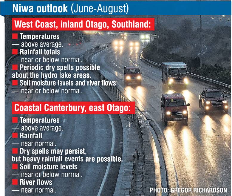
Niwa meteorologist Ben Noll said during June, July and August, rainfall was expected to be near normal in the east of the South Island, and near or below normal in the west of the island.
As a result, soil moisture levels were equally likely to be near normal or below normal in the west and east of the South Island.
‘‘Although dry spells may continue to occur, periodic heavy rainfall events are possible.
‘‘Some of the heavy rainfall events could be a result of atmospheric rivers of moisture making landfall in New Zealand, particularly in eastern areas, which increases the risk for flooding events — a point of difference from previous recent outlooks.’’
Niwa’s latest Seasonal Climate Outlook also showed the weather was likely to be warmer than usual across Otago and Southland, over the next three months, bringing the possibility of fewer cold spells and frosts.
‘‘While cold spells and frosts will occur, as is typical during winter, they may be infrequent.’’
He said that the warmer temperatures would be partly driven by air pressure, which was predicted to be higher than normal to the south and east of the country.
‘‘This is expected to be associated with more westerly and northeasterly quarter winds than normal through the season.’’
However, he said now that El Nino Southern Oscillation (ENSO) conditions were ‘‘neutral’’ in the equatorial Pacific Ocean, there might be more variability in New Zealand’s weather patterns over the coming season.
‘‘During May, convective forcing was influenced primarily by the active phase of the Madden-Julian Oscillation (MJO) over Africa and the Indian Ocean, before propagating eastward to end the month.
‘‘Since ENSO-neutral conditions are occurring, the MJO is expected to be a primary mode of climate variability over the coming season.
‘‘The MJO can influence the jet stream pattern, which influences the likelihood for weather systems to approach New Zealand from the Southern Ocean or the subtropics.
‘‘During June, the MJO will be active over the Pacific to start the month before moving towards Africa and the Indian Ocean later in the month.
‘‘This may be associated with a more settled weather pattern in New Zealand during the second half of the month.
‘‘During July, forcing may reemerge over the Pacific, which would drive more regular low pressure systems for New Zealand.’’


