


Corsair Bay/
Motu-kauati-iti
Lyttelton,
Canterbury
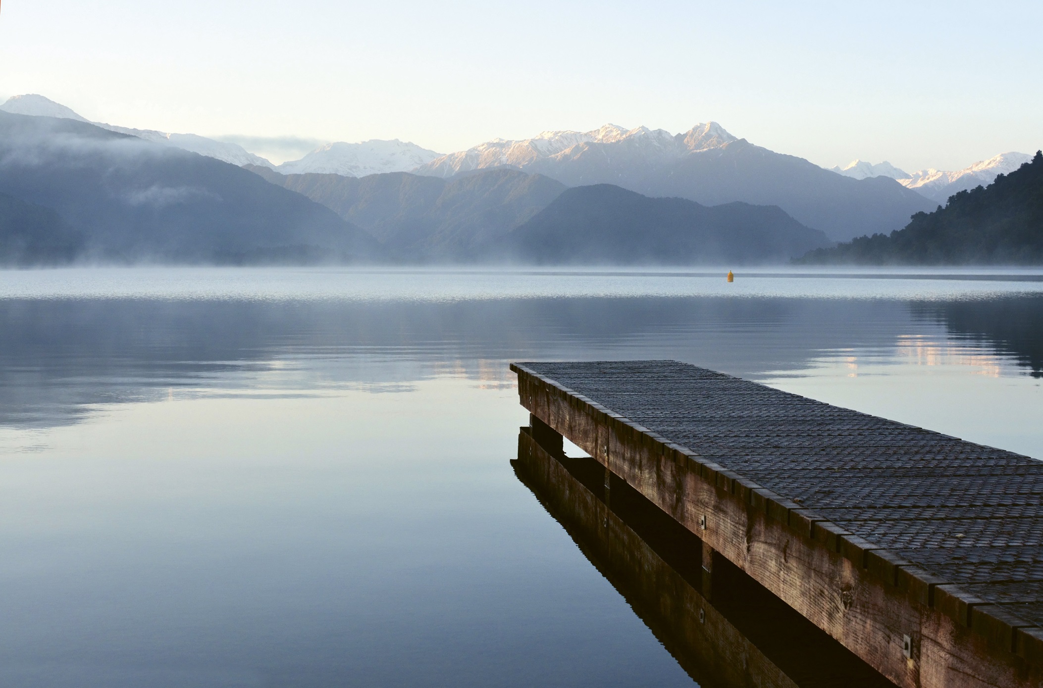
It's easy to imagine corsairs of old coming ashore at Corsair Bay given it’s a small, sandy cove surrounded by steep, bush-clad hills. However, this gorgeous spot wasn’t named because pirates once plied their trade here. Rather it takes its name from a ship that was wrecked in the bay in 1861.
On a gloriously calm, sunny summer’s day it’s hard to imagine how the Corsair came to grief here as the bay is a picture of tranquillity. Out on the pontoon, sunbathers laze while being cooled by the odd splash created by one of their mates popping a bomb into the water.
Up on the reserve above the beach, families laze on blankets stretched out to make the most of a spot of sand-free picnicking. For me, it was a coffee from the van in the carpark and down the multiple sets of stairs to the water’s edge. It’s a bit of a stroll down to Corsair Bay from the road or the carpark, but this brings with it the benefit of there being no access for boat launching at the beach, making it a safe place for swimmers.
Given it was such a hot day, the water was refreshingly cool and clear. The gradient is gentle so the shallows are a great place for kids to paddle and swim. On the outer edges of the bay are a series of buoys inside which no power craft are meant to venture, so there’s a good-sized space in which to stretch out for a swim within view of Ōtamahua/Quail Island on the other side of the harbour, which served as Canterbury’s quarantine station from 1875.
After a decent swim and a bit of a laze in the sun, it was a treat to be able to dry off and get dressed in the wonderfully old-school changing rooms before making the trek back up the hill to the car.
• Editor’s note: A health warning was issued at the weekend for Corsair Bay due to unexpected wastewater overflow blamed on bottles being put in public toilets. Health NZ warns against swimming in the bay. The Christchurch City Council says the water needs to be tested. Water quality updates can be found at lawa.org.nz
Corsair Bay
At a glance
Getting there
From Lyttelton, head west on SH74. At the roundabout, take the first exit onto Simeon Quay. After 400m, turn left onto Brittan Tce, which then becomes Park Tce. After 1.7km, make a sharp left-hand turn into Corsair Bay reserve.
Parking
Yes, on two levels above the bay.
Toilets
Yes.
Changing rooms
Yes.
Showers
Yes.
Kid friendly
Yes, as the water drops off gently, and there’s a playground by the lower carpark.
Dog friendly
Yes, except between 9am and 7pm from 1 November to 31 March.
Safety advice
The carpark can get really busy here, so keep your wits about you when crossing it on foot.
Long swim options
Chuck a tow float on, and tuck into the coast to avoid boat traffic, then take on the old Ocean Swim Series Triple Crown course from Corsair to Cass and Rāpaki Bays. Corsair to Cass is about 750m, then it’s another 1km around to Rāpaki so the return trip will easily give you 3.5km.
Lake Kaniere
Kaniere,
West Coast
Just 30 kilometres southeast of Hokitika, Lake Kaniere is paradise for swimmers. From its waters there are views of mountains on three sides, and its banks are covered in native bush right down to the water. The lake’s water is really clear and is so clean that it provides drinking water for nearby Hokitika. The bottom of the lake is sandy, so getting in and out is comfy on the feet.
Lake Kaniere is one of the few lakes in the country that has dedicated swim zones in it, but it also has plenty of other little surprises to serve up to anyone willing to explore a little.
The main swimming area on the lake is at Hans Bay. In fact, it covers pretty much all of Hans Bay as far as the jetty. It will come as no surprise that jumping into the lake from the end of the jetty is a ritual for most people who come to swim here.
As the bay is a swim zone, getting a long swim is pretty easy if you zigzag around its shores then head out to circumnavigate the two small, tree-covered islands just out from the boat ramp. Speaking of the boat ramp, there will be some vessels about, but they should be sticking to 5knots (or slower).
The other dedicated swim zone is around the lake to the west at Sunny Bight, but I suggest parking up and taking the track down to Canoe Cove instead. The carpark is just opposite the junction of Hans Bay Road and Mill Road, and from there a 650-metre track, some of which is on boardwalk, leads down through kahikatea and rimu forest to the cove.
There’s a small, sheltered sandy beach where you can leave your gear while you head off for a swim. I recommend heading out to the east as there’s a ski lane to the west, although with a reasonable-sized 5-knot zone buffer.
On days when the wind is up on the lake, there’s yet another swimming option nearby. From Hans Bay, head south along Dorothy Falls Road for about 3.5 kilometres where you’ll find Dorothy Falls. There’s a carpark next to the bridge, and from there it’s a 2-minute walk to the foot of the falls.
The falls have several different levels and they drop an impressive 64 metres. At their base is a mint little plunge pool that is perfect for swimming in. Just take care getting across the rocks as they can be a bit slippy.
Lake Kaniere
At a glance
Getting there
From Hokitika, head southeast on Hampden Street. After 1.4km, turn right onto Town Belt East, then do a quick dogleg left onto Kaniere Rd. After 3.8km, turn left onto Lake Kaniere Rd. Continue for 13km then, at the head of the lake, take a slight left onto Hans Bay Rd. Follow the road around to Hans Bay.
Parking
Yes, at Sunny Bight, Hans Bay Jetty, the head of the Canoe Cove track and by Dorothy Falls.
Toilets
Yes, at Hans Bay Jetty.
Changing rooms
No.
Showers
No.
Kid friendly
Yes.
Dog friendly
No.
Sandflies
Don’t forget the insect repellent and long-sleeved clothes.
Safety advice
There are a number of dedicated water-ski zones around Lake Kaniere. They’re all marked so take note of where they are and stay away from them.
Long swim options
A loop of Hans Bay as described will give you a reasonable hit out.
Rakaia Gorge
Windwhistle,
Canterbury
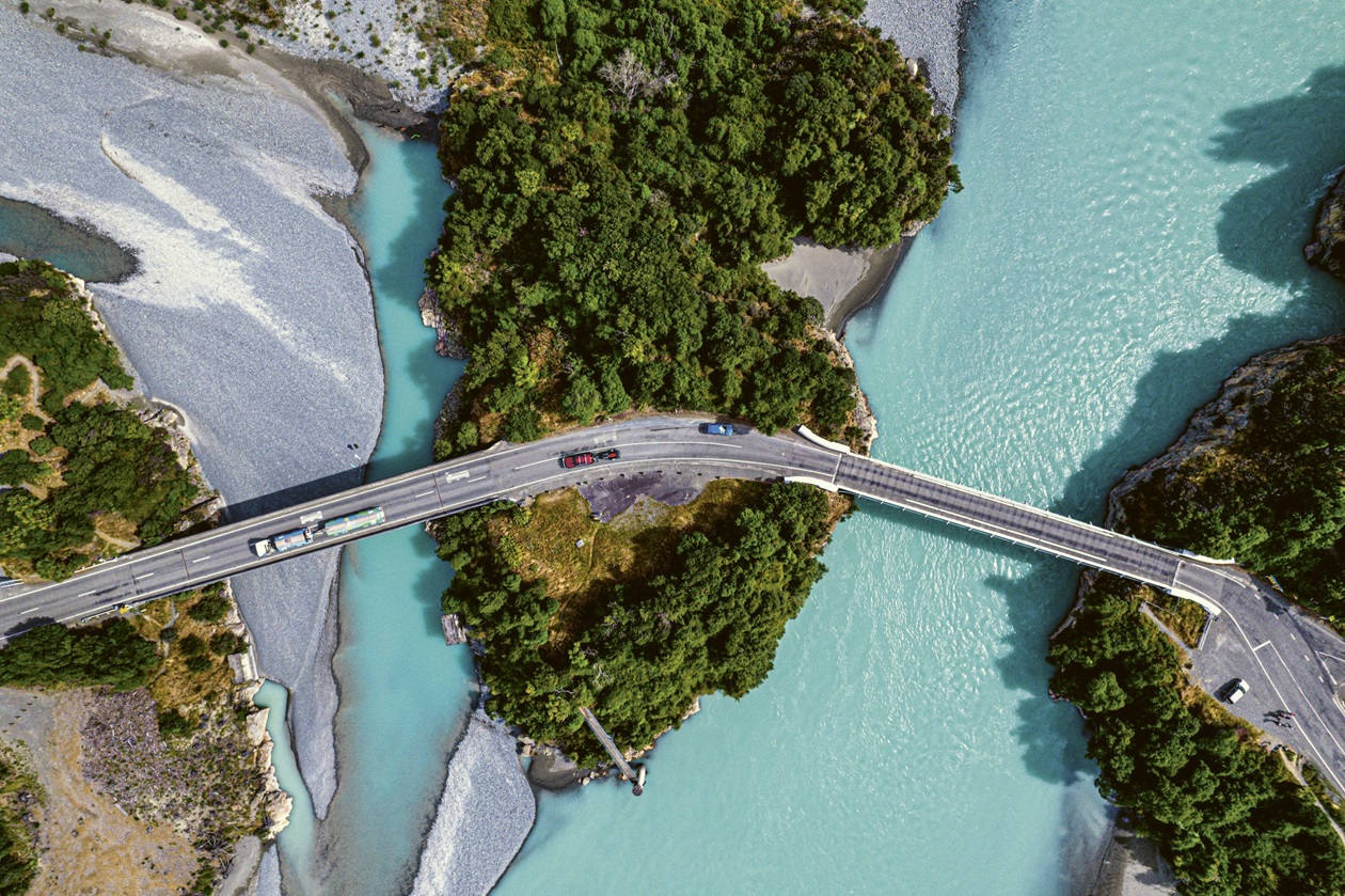
The vast braided river that threads its way across the Canterbury Plains is almost unrecognisable as you stand on its banks and peer down into the Rakaia Gorge. Here, the Rakaia River more resembles the pristine Lake Pukaki, than the pebble-clad meanderings of its waters both up- and downstream. That’s because its waters have similar glacial origins flowing from the melted ends of the Lyell and Ramsay Glaciers in the Southern Alps.
Thousands of years of glacier and river flow have slowly worn down the surrounding rhyolite and andesite rock to create the spectacular cliffs that surround the river here, while the fine particles of glacial flour give the water its intense turquoise colour.
At first glance, from the height of the road, the river here doesn’t look very swimmable. It’s deep and in places very fast flowing, but I decided that it definitely warranted closer inspection. Given it was a Sunday at the end of the summer holidays, the area was really busy when I visited. That meant there was plenty of traffic crossing the two bridges that span the gorge, and it took me a while (and a couple of turns crossing the bridges) before I worked out where to park in order to access the river.
I’m sure there’s an easier way, but I ended up parking at the large lookout about 400 metres before the bridge and walking down the track from there. I heartily recommend doing this in a sturdy pair of shoes as it’s a bit of a mission and the riverbed is pretty rocky.
When I got down to the river, I decided there was a bit much water flowing for my taste, although there were people dipping close to shore. It turned out I hadn’t wasted a clean pair of togs though, as there’s quite a big swimming hole under the concrete bridge, where water flows in and sort of gets trapped until the river level rises and flushes it out. It provided a safe, slightly warmer yet still clean alternative to chucking myself in the river.
Being in the water right under the bridge felt kind of strange, as the views of the river and the gorge were stunning but all the while I knew there was a plethora of utes, caravans and campervans rolling along overhead!
Rakaia Gorge
At a glance
Getting there
From Christchurch, take SH73 to Yaldhurst. At the roundabout, take the second exit and stay on SH73. After 34km, turn left onto SH77. Continue for 40km to Rakaia Gorge.
Parking
Yes, at several points on both sides of the bridges.
Toilets
Yes, in the carpark on the eastern side of the old bridge.
Changing rooms
No.
Showers
No.
Kid friendly
Yes, in the protected swimming hole under the bridge.
Dog friendly
No.

The book
Images and text from Jump In: An insider's guide to New Zealand's best beaches, lakes, rivers, pools and hot springs by Nicola McCloy, published by HarperCollins NZ, RRP:$49.99.


