
PHOTO
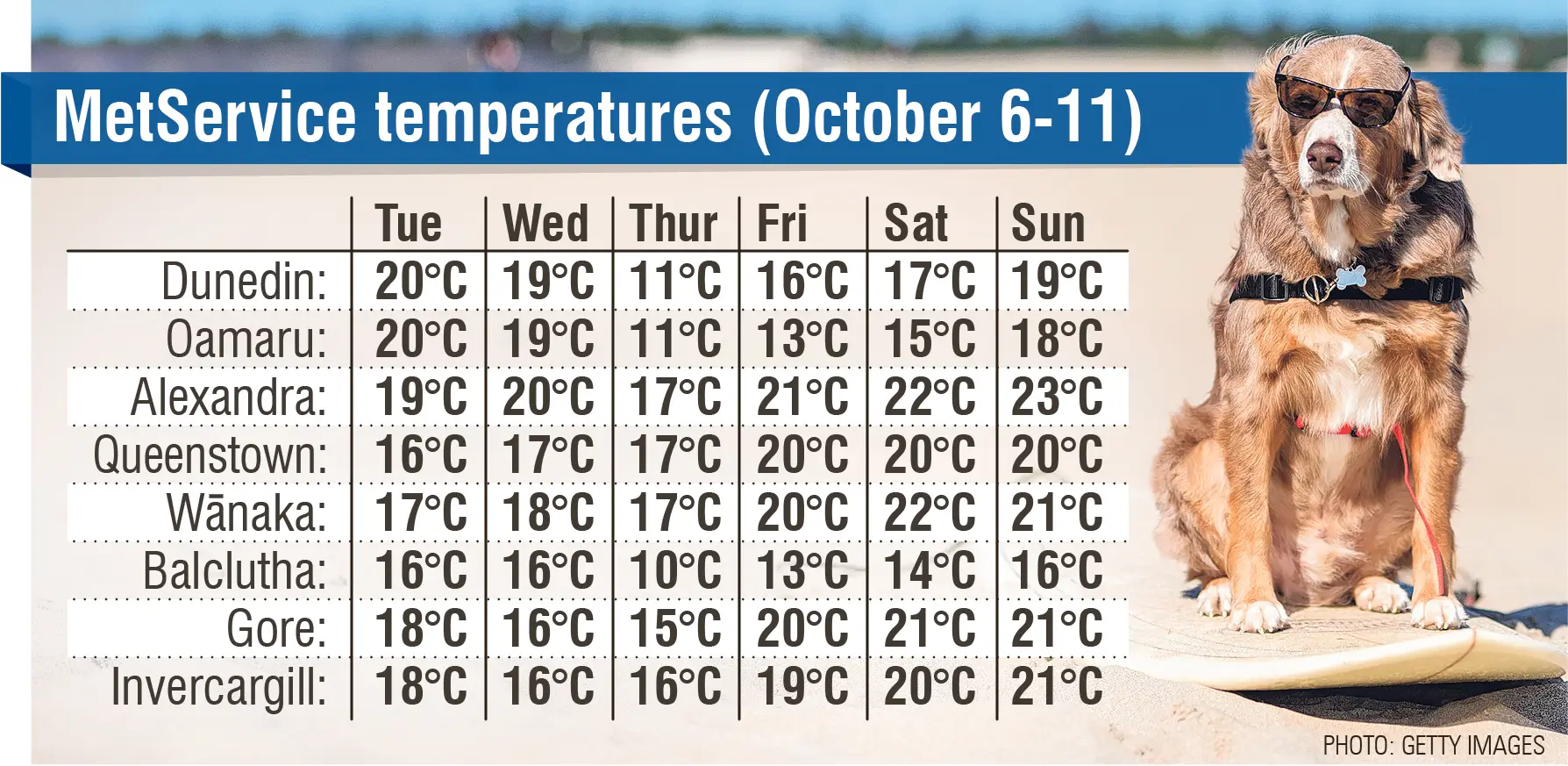
Apart from a couple of proverbial “flies in the ointment”, MetService is forecasting a warm week in Otago and Southland, with “well above average” temperatures reaching up to the 20s.
MetService meteorologist Lewis Ferris said there would be more of a northwesterly wind flow, which would help bring the temperatures up during the week.
All days were expected to be fine, except Wednesday, when there would be some showers across parts of the southern regions.
“There’s a few little flies in the ointment, if you will, but for the most part, it’s pretty good.”
He said anything above 14˚C in Invercargill, 15˚C in Dunedin, and 17˚C in Central Otago would be above the average temperature for this time of year.
Reaching 21˚C in Invercargill, 20˚C in Dunedin and 23˚C in Central Otago was “well above average”, he said.
“So that’s pretty good for them. That is warmer than average for this time of year.
“It’ll give people a nice little taste of the more summery conditions that we sometimes see in spring.”
Mr Ferris said the temperatures were unlikely to break October records, because there had been temperatures closer to 25˚C in Invercargill in the past.
However, there was still plenty of time for that to happen.
He said the warmer, drier and calmer weather would be especially welcomed by Southlanders.
“I know Southland’s been doing it pretty rough in terms of getting a lot of rainfall.
“They had a good month or 6-week stretch, where there was just steady amounts of rain, and there have been reports of the ground being just sodden and farmers are having to deal with that.
“So this week’s weather will be a bit of a break from that.”
While northwesterly winds were fuelling the typical warm foehn wind around the South, part of the warmth was also caused by a lack of wind in the region.
“We don’t have a supremely warm air mass that’s being dragged down from the north.
“It just kind of seems to be the longer sunlight and clear skies.
“Getting the sun higher in the sky does mean that the land heats up more readily, and that does mean that the air temperature gets to nicer numbers in the afternoon when there’s not too much in the way of wind around.”
While the longer-term forecast appeared to show the calmer and warmer weather looked to continue into next week, Mr Ferris said it was still too far out to guarantee.
“It has a sort of high pressure flavour to the country next week, but that doesn’t mean that we won’t see some weather move in.
“Maybe we shouldn’t try and get too ahead of ourselves in terms of next week.”