PHOTO
A balmy Dunedin November is set to turn into a sweltering start to summer, with temperatures expected to reach the high 20s this weekend.
The same weather patterns that have brought a record run of 25degC-plus days to Cromwell have brought a run of six 20degC-plus days to Dunedin, which started on November 25.
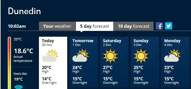
MetService is predicting Dunedin's run to continue, with the next 10 days forecast to be above 20degC, including a sweltering 27degC high predicted for Saturday.
MetService communications meteorologist Lisa Murray said a ridge of high pressure was staying over the country for a "quite unusual" length of time.
The high pressure system had brought with it northwesterly winds, which were associated with warm temperatures.
The run of hot weather was also heating up the ground, which made temperatures even warmer again.
Evening cloud was also stopping the heat from escaping.
At Dunedin Airport the average temperature for November had been 13degC, which was 1.5degC higher than the average of 11.5degC.
This was a "significant difference", she said.
It was also a dry November with 27.2mm of rain falling so far compared to a monthly average of 62mm.
Dunedin's sweltering start to summer could be a sign of things to come, as Niwa is predicting La Nina will bring warmer than usual conditions across the South Island.